
News
Behind the Headlines
Two-Cents Worth
Video of the Week
News Blurbs
Articles
Testimony
Bible Questions
Internet Articles (2015)
Internet Articles (2014)
Internet
Articles (2013)
Internet Articles (2012)
Internet Articles (2011)
Internet Articles (2010)
Internet Articles
(2009)
Internet Articles (2008)
Internet Articles (2007)
Internet Articles (2006)
Internet Articles (2005)
Internet Articles (2004)
Internet Articles (2003)
Internet Articles (2002)
Internet Articles (2001)


![]() an
has been asking,—and
hypothetically answering—the question: "Where was
the Garden of Eden located?" for at least the last
one thousand years. There have been as many answers to the question
as times the question has been asked. Few of the suppositions
are based on the Bible, and even fewer are based on science
since there is a consensus among many church people that science
and religion mix about as well as oil and water. And, because
an
has been asking,—and
hypothetically answering—the question: "Where was
the Garden of Eden located?" for at least the last
one thousand years. There have been as many answers to the question
as times the question has been asked. Few of the suppositions
are based on the Bible, and even fewer are based on science
since there is a consensus among many church people that science
and religion mix about as well as oil and water. And, because.jpg) contemporary Bible scholars cannot accurately pinpoint the precise
location of the headwaters of the four rivers that came out
of biblical Eden, many people—Christians as well as agnostics—tend
to view the Garden of Eden as an imaginary place in a
mythical story of creation.
contemporary Bible scholars cannot accurately pinpoint the precise
location of the headwaters of the four rivers that came out
of biblical Eden, many people—Christians as well as agnostics—tend
to view the Garden of Eden as an imaginary place in a
mythical story of creation.
However, since the Word of God declares that Eden was a real place [Isaiah 51:3; Ezekiel 28:13,31:9; Joel 2:3] we must conclude that it was. The geographic location of the Garden of Eden is vaguely described in Genesis 2:10-14. "And a river went out of Eden to water the garden; and from thence it was parted and became four heads. The name of the first is Pishon; that is it which compassed the whole land of Havilah, where there is gold...And the name of the second river is Gihon; the same is it that compasseth the who land of Cush. The third river is Hiddekel (the Tigris) which goeth toward the east of Assyria. And the fourth river is Euphrates."
The name Eden, like Nod (the land to which Cain was exiled) is thought by many to be simply a generic word for a generic, rather than specific, place because Nod [nôd] is derived from the Akkadian word nûd, which denotes a migration. Additionally, the derivative nôd parallels the root word describing a homeless wanderer. God cursed Cain [Genesis 4:2] and condemned him to suffer the life of a fugitive, to wander aimlessly throughout the land as a nomad. For that reason, Genesis 4:16 could be correctly paraphrased to read: "And Cain deliberately rejected God, who sent him forth into the land to wander homelessly as a fugitive."
Eden is derived from the Akkadian word edinu which comes from the Sumarian word eden, which means fertile plain or steppe. That word is a transliteration of the Hebrew word, ádan, which means garden of delight. Biblical names of places are many times geographic descriptions.
Based
on the geographic description of Eden in Genesis, men have searched
for the Garden of Eden for the last 200 years. Some to
confirm its existence. Some to "prove" the Bible. Some
to look for gold; and others to find the fountain of youth or
perpetual life which they are convinced still exists in that spot.
Many students of Scripture are convinced that the Garden was located
in the Persian Gulf area based on the text of Genesis 2:10-14
because two of the four rivers coming out of the Garden—the
Tigris and the Euphrates—water the delta of the Arabian peninsula
before flowing into the Persian Gulf. 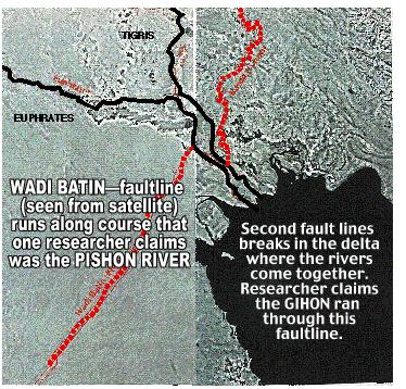 One
such advocate of the Garden being located in the Euphrates and
Tigris delta is Dr. Juris Zarins, an archaeologist. Zarins
formed his Edenic hypothesis from the writings of Assyriologist
Benno Landsberger who, in 1943, decided that, from ancient
Assyrian-based names, it could be safely concluded that the Garden
was located in the fertile Euphrates delta. Landsberger,
like Zarins, believe that seismic events over the ages
caused the formation of the Persian Gulf. As the land mass split,
the Garden of Eden was flooded by incoming ocean waters
and now lies submerged under the Persian Gulf.
One
such advocate of the Garden being located in the Euphrates and
Tigris delta is Dr. Juris Zarins, an archaeologist. Zarins
formed his Edenic hypothesis from the writings of Assyriologist
Benno Landsberger who, in 1943, decided that, from ancient
Assyrian-based names, it could be safely concluded that the Garden
was located in the fertile Euphrates delta. Landsberger,
like Zarins, believe that seismic events over the ages
caused the formation of the Persian Gulf. As the land mass split,
the Garden of Eden was flooded by incoming ocean waters
and now lies submerged under the Persian Gulf.
To verify his hypothesis, Zarins began studying LANDSAT images of the Arabian peninsula. He decided that two of the rifts that appear on the satellite image (above, left) are the ghosts of two fossil rivers. The Wadi Batin rift that passes through Iraq to the southeast was, he concluded, the Pishon River. Another rift valley, in which the Karun River now flows, runs parallel to the Tigris on what appears to be a journey back to its headwaters in Turkey. Based on rifts caused by seismic activity, Zarins decided he had solved the theological puzzle of the century. There was only one serious flaw in Zarins' theory—the Bible. Genesis 2:10 pinpoints the geographic location of the Garden of Eden with scientific clarity. "And a river went out of Eden..." That means two things. First, the headwater of the first river originated in the Garden. Second, the water flowed out of the Garden towards the sea. And, while Zarins argued that the primary river was the Euphrates since it retained its name throughout time, the Bible, in verse 11 tells us that "...the name of the first river is Pishon, and it compasseth the whole land of Havilah..." Using Zarin's logic, we see his rivers flowing into, not out of, the Garden.
Archaeologists have been hard pressed to find the land of Havilah since the word in Akkadian simply means "sandy desert." Thus it could be anywhere in the Mideast or, for that matter, on the African continent, since the Ethiopians believe the Pishon originated there. Zarin's argument falters on other grounds as well. If there were no other faultlines in the Arabian peninsula, his argument might have some merit—the fact that the river flows into the delta and not out of it, notwithstanding.
Studying the geologic
history of the Arabian peninsula, we find the land mass geologically
divided into four very distinct terrains separated by suture
zones (points where the sedimentary layers collide as the
land masses move against each together). The first sedimentary
layer is metamorphosed volcanic residue containing granite. This
terrain is known as the Arabian Shield. The Shield
can technically be called the "basement" of the Arabian
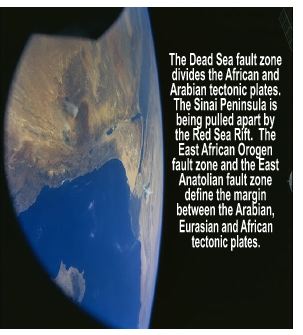 peninsula.
The largest part of the exposed portion of the Shield—about
575 thousand kilometers—is in Saudi Arabia. The Arabian
Shield is separated from the Nubian Shield by the Red
Sea Rift. Both shields are part of the larger East African
Orogen, which is the large plate upon which half of the African
continent rests. The East African Orogen is just one of
20 major tectonic plates upon which the continents sit. (This
explains why we find land masses that appear to have shifted in
two different directions at the same time.) As continental shift
and drift continues to occur in one direction, causing major
earthquakes, increased number of rifts in the Earth's crust, the
birth of volcanos and the creation of new island chains in the
oceans, separate land masses resting on those plates can experience
shifting in another direction on the top of the plates that results
in less severe seismic events. This dual action is one of the
things that causes confusion in how continental drift actually
happens.) The physical data, confirmed by LANDSAT imagery over
the past two or three decades confirm the tectonic plate movement;
and the manner in which the sea floor is still moving.
peninsula.
The largest part of the exposed portion of the Shield—about
575 thousand kilometers—is in Saudi Arabia. The Arabian
Shield is separated from the Nubian Shield by the Red
Sea Rift. Both shields are part of the larger East African
Orogen, which is the large plate upon which half of the African
continent rests. The East African Orogen is just one of
20 major tectonic plates upon which the continents sit. (This
explains why we find land masses that appear to have shifted in
two different directions at the same time.) As continental shift
and drift continues to occur in one direction, causing major
earthquakes, increased number of rifts in the Earth's crust, the
birth of volcanos and the creation of new island chains in the
oceans, separate land masses resting on those plates can experience
shifting in another direction on the top of the plates that results
in less severe seismic events. This dual action is one of the
things that causes confusion in how continental drift actually
happens.) The physical data, confirmed by LANDSAT imagery over
the past two or three decades confirm the tectonic plate movement;
and the manner in which the sea floor is still moving. 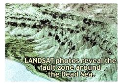 The
epicenter of the global tectonic seismic activity when Gottsland
began to spread apart eons ago appears to be in the area around
the Dead Sea. (If that proves to be true, then it can safely be
said that Israel is the center of the world.)
The
epicenter of the global tectonic seismic activity when Gottsland
began to spread apart eons ago appears to be in the area around
the Dead Sea. (If that proves to be true, then it can safely be
said that Israel is the center of the world.)
If you're wondering what tectonic plates have to do with the Garden of Eden, it is because the discussion shows precisely why two of the four rivers coming out of the Garden of Eden are missing.
Many Bible buffs—most of whom are lay people—have been asking the question for two hundred years: "Where are the Pishon and Gihon Rivers?" If they did not branch off of the Tigris and Euphrates just above the delta, where were they? Was Zarins correct in his assumption that the Garden of Eden now lies beneath the Persian Gulf? He was not. We know this because, as stated earlier, Zarins erred by failing to take into account that the source of the Pishon—and by extension, the Euphrates, Tigris and Gihon—which would be found at the source and not where those rivers empty into the Persian Gulf. The headwaters of the Euphrates remains in the high, fertile steppes of Turkey.
.jpg) The
map (above, left) shows the most logical course of the Pishon
and Gihon Rivers as they flowed from the high, fertile steppes
of Greater Mount Ararat in Turkey. The Pishon likely flowed into
the Nile basin and the Gihon flowed through what is now the Jordan
River into the Dead Sea, cutting a course through Israel into
what, after several seismic events, became the Gulf of Aqaba.
Or, it may be that the Gihon cut through what is now the Gulf
of Suez, on its way into the rift that became the Red Sea. But
regardless if the Gihon's path was the Gulf of Suez or the Gulf
of Aqaba, the Red Sea Rift was the ancient riverbed of the Gihon
as it emptied into the ocean.
The
map (above, left) shows the most logical course of the Pishon
and Gihon Rivers as they flowed from the high, fertile steppes
of Greater Mount Ararat in Turkey. The Pishon likely flowed into
the Nile basin and the Gihon flowed through what is now the Jordan
River into the Dead Sea, cutting a course through Israel into
what, after several seismic events, became the Gulf of Aqaba.
Or, it may be that the Gihon cut through what is now the Gulf
of Suez, on its way into the rift that became the Red Sea. But
regardless if the Gihon's path was the Gulf of Suez or the Gulf
of Aqaba, the Red Sea Rift was the ancient riverbed of the Gihon
as it emptied into the ocean.
There
is a very significant reason for making certain that we are correct
in the general location of the Garden of Eden. The reason for
that will become apparent very quickly. But first, we know from
studying the topography of the terrain in the Mideast that the
Euphrates and the Tigris originate in the high, fertile steppes
of the Turkish mountain range we know as Great and Little Mt.
Ararat. 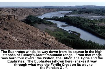 The
tallest peak is known as Great Ararat. It rises 16,854 feet above
sea level. It's companion peak, known as Little Ararat, is located
seven miles to the east on the Aras Plain. It stands 12,782 feet.
A third peak, Mt. Agri, is the main peak in Turkey and is 18.2
miles from Great Ararat.
The
tallest peak is known as Great Ararat. It rises 16,854 feet above
sea level. It's companion peak, known as Little Ararat, is located
seven miles to the east on the Aras Plain. It stands 12,782 feet.
A third peak, Mt. Agri, is the main peak in Turkey and is 18.2
miles from Great Ararat.
Two
of the three mountains claim to be the final resting spot of Noak's
Ark. Mt. Ararat consists of two volcanic peaks—Great and
Little Ararat. The twin cones, which no longer possess craters,
overlook the points where Turkey, Iran and Armenia converge. During
the Cold War, Armenia was under Soviet control. The villagers
of Uzungil at the base of Mt. Agri on the Turkish side of the
border claim that a geological hollow discovered there in 1960
by Lihan Durupinar, a Turkish naval captain is Noah's Ark.
Several expeditions investigated the find and several publications, including Life magazine, covered the "Ark mound" story.
While explorers found metal artifact and other relics that clearly
indicate that human beings were at that location eons ago, there
are no reports that fossilized gopher wood or wood of any type
have been found at that location. Clearly, the evidence found
indicates only that man was there and something that man had "constructed"
had rotted and, over time, had disintegrated there. Does that
bulge
including Life magazine, covered the "Ark mound" story.
While explorers found metal artifact and other relics that clearly
indicate that human beings were at that location eons ago, there
are no reports that fossilized gopher wood or wood of any type
have been found at that location. Clearly, the evidence found
indicates only that man was there and something that man had "constructed"
had rotted and, over time, had disintegrated there. Does that
bulge  in
the Earth represent the final resting place of Noah's Ark after
the Great Flood? Perhaps. But there is even a more likely sighting
on the Armenian side of Great Ararat.
in
the Earth represent the final resting place of Noah's Ark after
the Great Flood? Perhaps. But there is even a more likely sighting
on the Armenian side of Great Ararat.
In 1973 the CIA was scanning Soviet troop movements in Armenia, close to the Turkish border with a KH-9 remote-sensing satellite. The eye-in-the-sky detected a black object protruding from a rock ledge near the peak of Mt. Ararat. The CIA technicians could not identify the object which, they felt, could be just about anything. Whatever it was, they knew it didn't belong there. So they classified the photos—hundreds of them. In 1976 the KH-9 spycam was replaced with the KH-11 which can read a license plate on a car 100 miles below it. Between 1976 and 1990 the CIA took thousands of classified photos of the object protruding from the icy slope on Mt. Ararat's north side.
While the CIA never officially said, "This is Noah's Ark," there was a lot of speculation on the part of CIA Director James Woolsey as to the possibility that the CIA might have discovered Noah's Ark. Woolsey asked how much a more extensive investigation of the object would cost. CIA documents reveal that Woolsey felt the cost was too high for a six-month theological fishing expedition that could not be justified. The project was dropped but not the interest. Throughout the Bush-41 Administration years there were sparks of interest to find out whether the protrusion was the Ark, some other type of man-made structure or a strange rock anomaly, but not enough to kindle the fire needed to send an exploration team to Armenia to find out after the Iron Curtain was raised. George H.W. Bush's National Security Adviser Robert Gates showed photos of the Mt. Ararat "anomaly" to those attending a national security briefing for the first time in 1990. Several conversations about the Ark took place during Bush-41's term, between 1990 and 1992. But it was a red herring issue. Bush-41 was afraid that if they spent any appreciable amount of government money to investigate the object, the media would have a heyday in 1992 when he came up for re-election, arguing that Bush was spending taxpayer dollars to prove the Bible. (Of course, Bush-43's NASA scientists are spending billions of dollars to explore Mars in order to prove that God did not create life on Earth.)
President Bill Clinton declassified many of the documents and photos in 1995, but the media never got excited about the discovery of what might be Noak's Ark, and the story never grew legs.
The ancient Akkadian name for Armenia is Urata. Its Hebrew equivalent is Ararat. Ararat is both a land (2 Kings 19:37; Isaiah 37:38) and a mountain range. When the flood waters that covered the Earth receded, the Ark came to rest on the mountain of Ararat (Genesis 8:4). After 37 days in the Ark, Noah and his family came forth and offered a sacrifice to the Lord. Pleased by its sweet savor, God blessed Noah and his sons, and said to them: "Be fruitful and multiply, and fill the earth." (Genesis 9:1; NASB)
Was it irony, coincidence, or divine intent that God's instructions to Noah and his sons were the same instructions He gave to Adam: "Be fruitful and multiply, and fill the earth." (Genesis 1:28; NASB)? What's more, God repeated the instructions to Noah in the approximate place where He first gave them to Adam. That is why the Persians refer to Ararat as the cradle of the human race.
Was its God's plan to replenish the Earth from the same spot where He breathed life into man and carved woman from his rib? That appears to be the case since according to oral tradition, to Scripture and perhaps, according to thousands of CIA spycam photos of the as yet unidentified object on a wide shelf near the top of Great Ararat, "The ark rested in the seventh month, on the seventeenth day of the month, upon the mountains of Ararat." (Genesis 8:4; KJV).
Whether the Garden of Eden was located in the fertile steppes of Great Ararat, Little Ararat or Mt. Agri, mankind will not know until petrified remains of Noah's Ark are found. We can be reasonably certain from Scripture that the Ark came to rest in this general region—at the spot where the Pishon, the Gihon, the Tigris and the Euphrates sprang forth from the ground to water the Garden. When—and if—fossilized remains of the Ark are found in the mountains west of the Aras Plain, the remains will mark, for all time, the general location of the Garden of Eden. There should be little doubt in the mind of Christian believers that God fully intended to replenish the Earth from the same spot where creation originated

Copyright © 2009 Jon Christian Ryter.
All rights reserved.